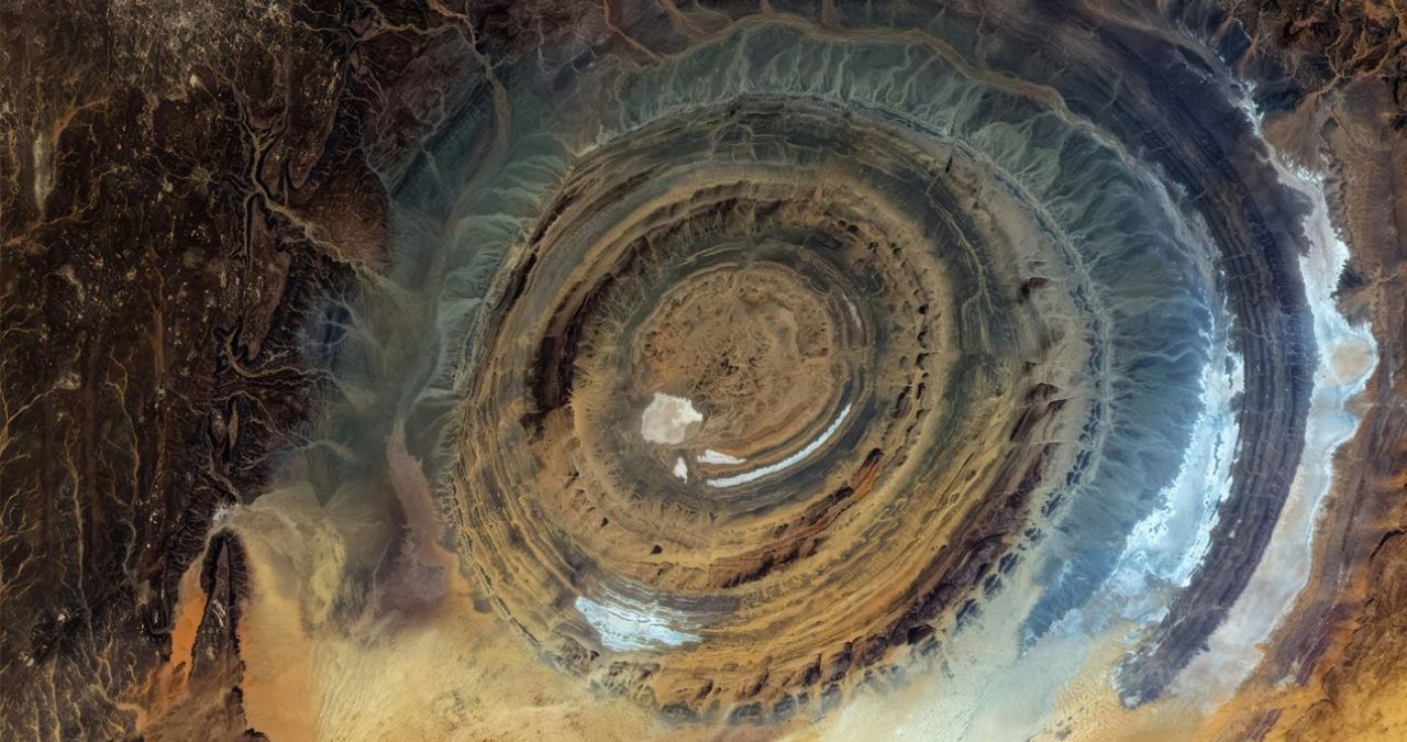
A geological formation in the Sahara Desert, long referred to as the “Eye of the Sahara” or the Richat Structure, has been the subject of renewed interest following explanations from NASA. First documented in the 1930s, the feature was once described as a giant buttonhole in the desert landscape. The Richat Structure, located near the town of Ouadane in the Mauritanian portion of the Sahara Desert, spans approximately 40 kilometers (25 miles) in diameter.
NASA officials stated that the formation was originally thought to be a meteorite impact crater due to its circular appearance. However, further geological analysis has determined that it is not the result of an extraterrestrial collision. The structure is instead a deeply eroded geological dome, formed by the gradual uplift of rock layers followed by millions of years of erosion.
Geological Origins and Discovery
The Richat Structure was first seen clearly from the air during early aerial surveys in the 1930s. Its distinct concentric rings, which create a bullseye or eye-like shape, made it a landmark for desert navigation and later for space missions. The formation became particularly well known after it was photographed from space by early astronauts, who used its large and symmetrical shape as a visual reference point.
Geologists have since dated the rock layers within the structure. The oldest exposed rocks in the center of the formation are sedimentary and volcanic in nature, dating back to the Proterozoic Eon, roughly 2.5 billion to 542 million years ago. The younger layers are progressively found toward the outer rings, indicating a history of geological activity and erosion.
How the Structure Formed
Scientists describe the Richat Structure as a symmetrical anticline, a type of fold in rock layers where the strata are arched upward. This was caused by the intrusion of magma deep below the surface, which pushed the overlying sedimentary rock layers upward into a dome. Over hundreds of millions of years, wind and water erosion stripped away the top layers, exposing the harder rock in concentric ridges.
The differing resistance of various rock types to erosion created the concentric rings visible today. Quartzite ridges, which are highly resistant to erosion, stand out as prominent circles, while softer rocks such as limestone and shale have been worn away to form valleys. This process has left the current bullseye pattern exposed at the surface.
Myths and Clarifications
The distinctive shape of the Richat Structure has led to various myths, including claims that it was a lost city or a landing site for extraterrestrial craft. NASA has clarified that these are not supported by scientific evidence. The feature is entirely natural in origin and holds no evidence of human construction or alien activity.
The structure was also incorrectly identified by some sources as the site of the legendary lost city of Atlantis. Plausible arguments linking the circular rings to descriptions of the city in ancient texts have been made, but no archaeological evidence exists to support such claims. NASA and geological authorities continue to classify it solely as a natural geological formation.
Scientific and Navigational Value
The Richat Structure has provided scientists with valuable insight into Earth’s geological history. The exposed rock layers offer a cross section of continental crust formation and erosion processes. It has also been used as a training site for astronauts, who learn to recognize geological features from orbit.
The structure remains a focal point for remote sensing studies. Its clear visibility from space has made it a useful calibration target for satellite imagery. Researchers continue to study the formation to better understand the processes of doming and erosion that shaped it, as well as its potential to reveal information about ancient climates and tectonic activity.
Looking forward, the Richat Structure is expected to remain an important site for both geological research and space mission training. Satellite monitoring and ground surveys will likely continue to refine models of how the structure evolved. Its status as a natural landmark, rather than a crater or artificial construction, is now firmly established in the scientific community.
Source: NASA